ENLACE overview
Predictions of long-term coastal evolution on decadal timescales are increasingly sought for adaptation planning in light of climate change and sea-level rise. Present and future needs demand the extension of process-based models beyond short-term time scales to assessment of long-term coastal changes. These models are already able to provide detailed analysis and prediction of morphological changes at short-term time scales. Still, further investigation is needed to bridge the gap between short-term hydrodynamic and transport processes, varying over hours to days, and morphological changes, often taking place over much longer periods. Thus, the importance of studying the medium to long-term (years to decades) morphological change and its effect on coastal sustainability stresses the need for new methodologies to support predictions over these time scales.
ENLACE will explore process-based models to identify the best strategy to simulate long-term coastal evolution of sandy coasts. That strategy will balance reductionism and synthesis to capture behaviors that provide the explanatory and predictive capabilities at an ‘appropriate complexity’ level. For that, a series of state of the art process-based models will be coupled to integrate both longshore (ShorelineS model) and cross-shore (XBeach-Duna coupled models) processes (Fig). The novel approach proposed within ENLACE will holistically explore long-term evolution of sandy coasts by also integrating aeolian processes and extending the cross-shore processes to the emerged coastal barrier. The results will contribute to predicting long-term coastal morphodynamics and guide policy makers and managers
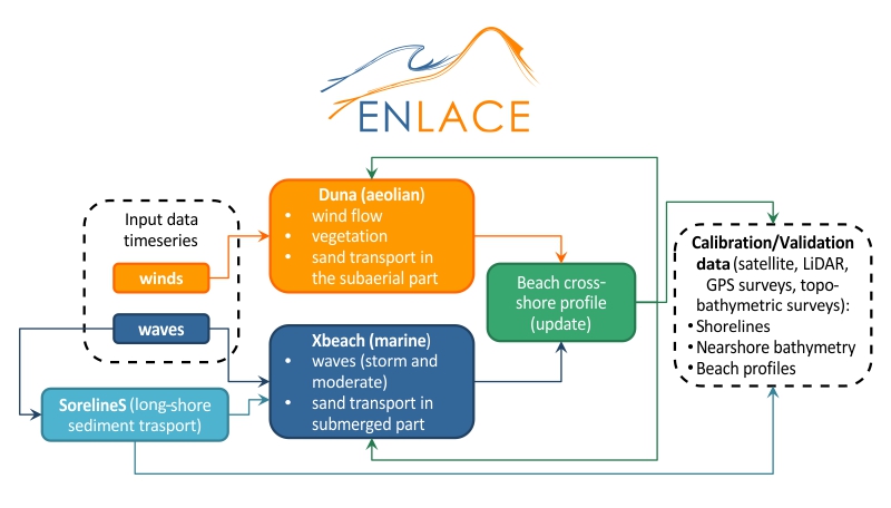
Two of the models to be used by ENLACE (ShorelineS and Duna) are being developed and will be tested and validated within the project. Validation will be done using long-term (i.e. years to decades) past morphological (1D profiles and shorelines) changes retrieved from pre-selected study sites. The morphological variability of the sites (from steep Portuguese beaches to dissipative Brazilian beaches) will allow testing the performance of the approach under different morphological conditions. Finally, the developed approach will improve process-based model predictions for long-term coastal evolution, accounting for the response of coastal systems to future climate and sea-level scenarios. ENLACE consortium is formed by two research groups working on coastal dynamics from two academic institutes (University of Algarve, Portugal and the Ceará State University, Brazil) and one institute dedicated to research dissemination (Ciência Viva Algarve, Portugal). Both research institutes will work together on formulating the holistic morphological evolution modelling approach by exploring the morphological evolution and responses of different study sites, while the collaboration with Ciência Viva will warrant the dissemination of the project’s progress and results among different stakeholder groups, and local managers.
Project Tasks
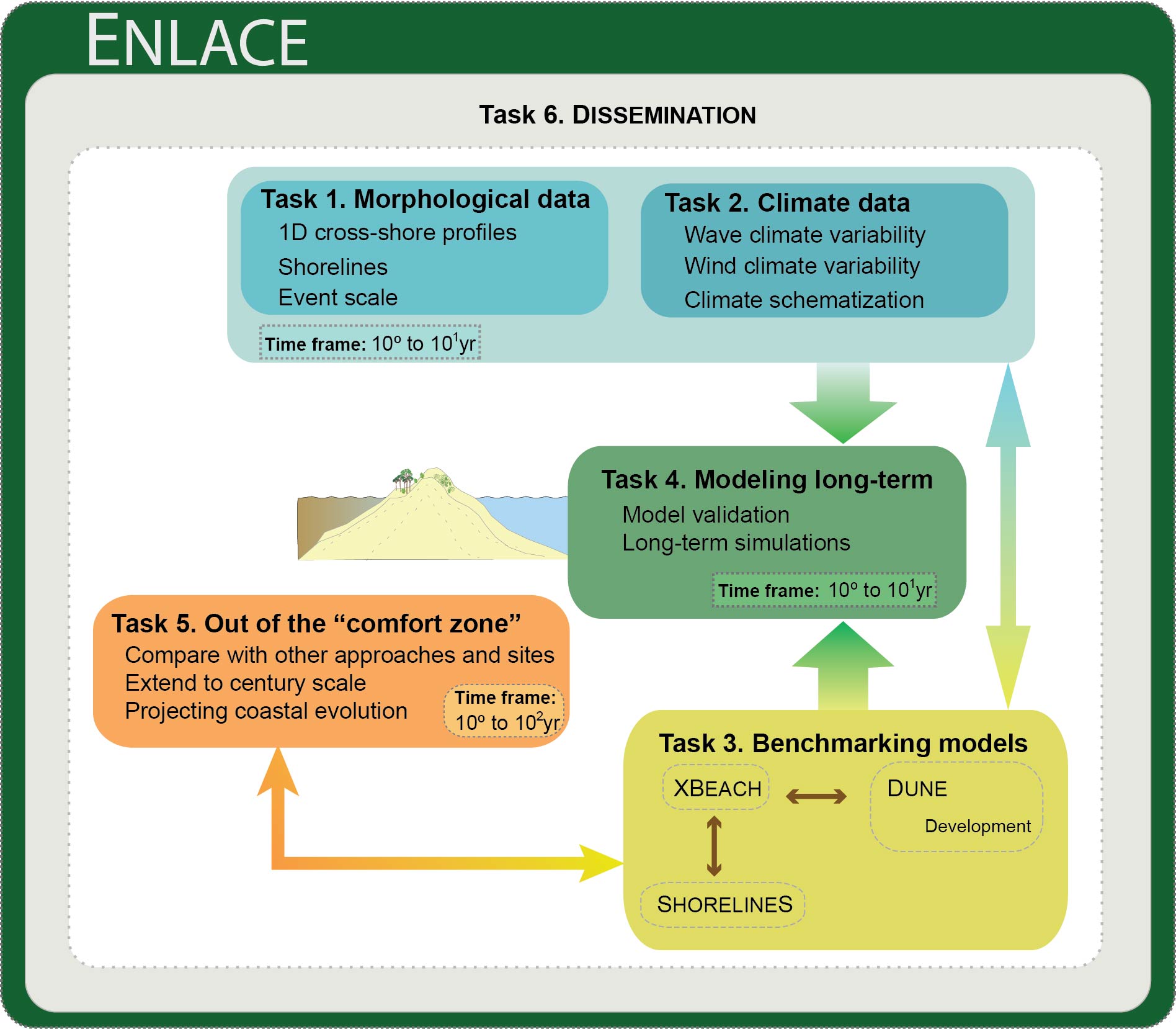
All activities within ENLACE are integrated in the following tasks (Fig):
T1. Long-term morphological evolution datasets
This task aims to collect all available data of barrier topography. The collected data will cover several decades and will be used to calibrate and validate the models in Task 4 about the long-term evolution of the selected sites. We will focus on particular areas of the Ria Formosa (Southern Portugal) that present elevated rates of progradation and different beach slopes (e.g. Barreta Island, Vila Real de Santo Antonio), on areas with available data (e.g. Praia de Faro), and on particular locations along the Ceará coast (Northern Brazil) with data availability (e.g. Praia do Icaraí) and contrasting morphologies (e.g. the dissipative Praias do Trairi).
Task 1.1. Long-term barrier profile (1D) evolution. This sub-task aims at producing long-term datasets of profile evolution at the selected areas. The profiles will extend from the foredune, reporting any changes at the dune area, to the closure depth of the beach. Available data will be complemented with new data derived from aerial photographs and satellite images. Topography will be derived from the first applying photogrammetry principles and from the second will be based on the optical response of the water. The advantage of using satellite images (1984-2014: Landsat, after 2014: Sentinel) is the possibility of deriving high temporal resolution data. Unfortunately, the high temporal resolution is associated with a low spatial resolution, which is lower for earlier years (30m for Landsat and 20m for Sentinel).
Task 1.2. Long-term shoreline evolution. The objective of this sub-task is obtaining high temporal resolution data on shoreline evolution. For that, polylines representing the shoreline will be obtained from aerial photographs. In order to increase the temporal resolution of the shoreline reconstructions, satellite images (Landsat and Sentinel) will be used. The polylines will map the position of shoreline indicators, the contact between the incipient vegetated dune and the beach, which have contrasting colors or reflectance values, and the contact between the water and the dry sand.
Task 1.3. Event-scale experiments and new profile surveys. This sub-task aims at measuring in situ new 1D profiles and map recent shorelines. In addition, surveys will be carried out to explore the aeolian dynamics at the study sites at event-scale to explore the relation between the beach sediment budget and the dune growth.
Milestones of T1
Long-term morphological evolution of cross-shore profiles
A dataset including all profiles from the pre-selected study cases will be elaborated. The profiles will be obtained from previous projects or extracted from satellite and aerial photography images in order to cover time scales of decades (preferable last 30 years). The temporal resolutions of profiles will depend on the quality of the images and frequency of surveying within previous projects. The dataset will show the morphological variability (1D) of the case study sites.
Long-term shoreline evolution
Shorelines covering the last 30 years will be extracted from aerial photographs and satellite images along the coastlines of the case study sites. This will generate a dataset of polylines per year showing the evolution of the selected stretches of coast.
T2. Climate variability and Schematization
This task has two main objectives: (i) collecting and analyzing the variability of measured or hindcast local wind and wave data, and (ii) exploring the best strategy for climate input reduction for the models (Task 3 and Task 4). In addition, local or regional sea-level variability will be assessed in order to characterize sea-level anomalies.
T2.1. Collecting and analyzing wave hindcast or instrumental data. This task aims at collecting observational and/or hindcast datasets of wave data. Preferably, observational data from wave buoys will be used; however, if the dataset is not complete, or the period of recording does not cover at least the last 30 years, it will be complemented with high-resolution hindcast wave data (e.g. for Portugal sites SIMAR-44 or the ERA-interim datasets, for Brazilian sites CPTEC-INPE dataset based on WaveWatch III). Collected data will be analyzed in order to understand its temporal variability (annual and interannual), identify the nature of extreme events and their associated return periods, to be contemplated within Task 2.3.
T2.2. Collecting and analyzing wind hindcast or instrumental data. This task aims at collecting available local wind observations for the last 30 years and if needed to fill the gaps using hindcast wind data from the ERA-Interim global atmospheric reanalysis (1979 to present). Wind data will be analyzed to assess annual and interannual variability of values above an estimated threshold of aeolian sediment transport.
T2.3. Wave and wind climate schematization. This sub-task aims at reducing the morphological model input of boundary conditions (waves, winds) to maintain the balance between model complexities, computational effort and processing capacity. The input reduction is needed to enable efficient simulations of morphological evolution over timescales of years to decades and will feed Tasks 4 and 5. Input reduction implies reducing the full climate datasets of a given region to a set of representative wave-wind conditions, running the models with these representative wave conditions for a smaller time period, while multiplying their effects on the morphology by a ‘morphological factor’ value (Roelvink, 2006). The latter depends on the frequency of occurrence of a particular wave-wind condition in nature. The results of the model using schematized climate conditions will be compared with the results from the same model running a reference climate (non-reduced cases) in order to assess different techniques and to decide which method reproduces simulated morphologies, i.e. in Task 4 and Task 5, more accurately.
Milestones of T2
Schematized boundary conditions
Wind and wave climate time-series will be schematized (reduced) using the most appropriate approach in order to minimize the time needed to run long-term morphodynamic models without missing relevant or representative conditions.
T3. Benchmarking long-term process-based models
This task aims at creating a set of idealized or reference cases to test the performance of the models (XBeach-Duna and ShorelineS for the 1D and the shoreline approach respectively) with long-term simulations and the capability of the models to show different results under different boundary conditions, as a test before the simulation of real conditions in Task 4. In addition, this task will aim at developing specific modules, namely the dune morphodynamics module of XBeach-Duna (Roelvink and Costas, 2019).
T3.1. Dune model development. This task aims at improving the Dune model that has been already coupled to XBeach (i.e. XBeach-Duna) in the frame of an ongoing collaboration with Prof. Dano Roelvink. In order to simulate the long-term coastal evolution, the aeolian compartment must also be integrated. In this regard, a process-based Dune model was developed in Matlab and coupled to XBeach (Roelvink et al., 2009). The model computes aeolian sediment transport based on the variable wind shear stress across the subaerial 1D profile, including the effect of tide-related moisture, armouring (Hoonhout and Vries, 2016), slope angle (Kroy et al., 2002), mean grain size (Bagnold, 1956), and vegetation (Durán and Moore, 2013). The model includes the changes in the vegetation cover by introducing growth rates and survival thresholds related to erosion and sediment burial (Durán and Moore, 2013).
T3.2. Benchmarking long-term models. This subtask represents the core of the proposal as it will explore the best model settings for different idealized cases based on different wave conditions and profile and shoreline configurations. In this regard, it will evaluate to which extent model settings are capable of reproducing observed beach morphodynamics. XBeach has been widely applied to simulate beach and dune erosion at event scale. Yet, it has been proven by fewer examples that the model, using optimal settings, can be also applied to simulate beach recovery (Daly et al., 2017; Pender and Karunarathna, 2013), essential to reproduce natural erosion-recovery cycles displayed by beaches at time scales greater than the event. In addition, this subtask will evaluate different settings depending on the beach profile morphology. It has been found that steep beaches demand extra adjustments of the model relative to more dissipative beaches (Vousdoukas et al., 2012), needing further testing and validation (Daly et al., 2017; Elsayed and Oumeraci, 2017). In addition, this subtask will explore the best way to integrate long-term shoreline and profile evolution by coupling ShorelineS and XBeach-Dune models.
Milestones of T3
Further development on Dune model
Duna model will be improved by adding complexity to the process of sediment transport.
Benchmarked models
The models will be set up for idealized cases in a way to test the capability of the models to run long-term conditions under simple situations but including different beach morphologies ranging from reflective, steep beaches, to dissipative beaches with gentle slopes.
T4. Modeling long-term coastal evolution
This task will test the capability of the models to reproduce long-term coastal evolution using the settings defined within T3.
T4.1. Downscaling of hydrodynamic boundary conditions. This subtask aims to obtain local wave climate conditions at locations where buoy measurements or hindcast data are not available at a local level to obtain the representative local wave climate. Therefore, ocean wave databases ought to be downscaled, by modeling wave propagation, to increase the spatial resolution and simulate the wave transformation processes.
T4.2. Validation of models. The test will be grouped according to the morphodynamic response of the barrier: berm formation, beach erosion, beach slope variability and dune growth. The latter will help to discriminate how well the models perform at the different zones and feed back to T3.1 and T3.2 if model settings must be improved. The latter is particularly important for the case of steep beaches where it is known that XBeach demands extra adjustments of the relative to more dissipative beaches (Vousdoukas et al., 2012). The accuracy of model simulations will be assessed using a Brier Skill Score (BSS), which has become a common practice within coastal numerical modelling. The BSS will compare a series of measured and simulated profiles using different settings. Simulated shorelines using ShorelineS will be validated using shorelines mapped from aerial photographs or satellite images.
T4.3. Simulating long-term coastal evolution. Once the models have been set up, and the climate conditions are schematized over the selected period of time, they will be run to simulate the long-term evolution of the selected study sites and to actually demonstrate the capability of the models, which in this case implies the reconstruction of the evolution of the cross-shore barrier profile (XBeach-Duna) and the shorelines (ShorelineS) over time.
Milestones of T4
Validated models
All models will be run for a series of particular conditions in order to validate simulation results against a number of chosen morphological conditions. 1D profile and shorelines from the compiled dataset will be used to validate the results of the simulations.
Long-term coastal simulations
Optimized model setup will be used to simulate long-term coastal evolution for all the case study sites once the models have been validated.
T5. Performing out of the “comfort zone”
This task aims at testing the performance of the model out of its original frame, namely by running the models using available datasets from alternative locations. In addition, a forum of discussion on model performance will be created to evaluate the performance of the models used within the present project against alternative models developed by other institutions. The objective is to understand which models are more adequate in what and under what circumstances, by bringing the results of the effort of developing long-term models of coastal evolution together.
In addition, this task will simulate long-term coastal evolution at century time scales, in order to test the models´ performance and the schematization approach at larger time scales. For that, we will use the data produced within the Twentieth Century Reanalysis Project – 20CR, a global reanalysis dataset spanning a portion of the nineteenth century and the entire twentieth century (1861 – near present). Despite the coarse spatial resolution of this dataset, it is extremely important to evaluate such an application, mainly because it implies an additional effort to schematize climate conditions with higher variability than the decadal record. Indeed, by expanding the temporal scale of the dataset, many important climate events (e.g. 1930’s dust bowl droughts) will be captured. In this case, we will use old maps with quantitative information to validate the long-term evolution (e.g. Faro-Olhão Hydrographic Map of 1885).
Finally, this task will test the performance of the models simulating long-term coastal evolution. For that, available projections of sea level, winds and waves for the different climate scenarios (e.g. projections generated by the Joint Research Centre) will be used as boundary conditions, separately (wind-wave projections without sea-level projections and vice versa) and combined (both sea level and wave-wind climate projections for the same scenario), after being schematized using the knowledge obtained in Task 2.
Milestones of T5
Century scale simulations of past coastal evolution
The models will be tested out of their comfort zone by running them longer than the time-scale of decades. Shorelines showing the evolution of the last century will be collected and the models will be run in order to test their capability at longer time-scales. The simulated shorelines will be then compared with the ones obtained from historical sources.
Projections of coastal evolution
Once the models have been tested to hindcast morphological evolution of the sandy coastal areas under evaluation, they will be used to forecast the evolution of the coast using available future climate scenarios.
T6. Dissemination
This task aims to disseminate the outputs from the project both to (i) the general public, including stakeholders and end users, through the elaboration of outreach activities, and to (ii) the research community by participating in international conferences, workshops, publishing in international journals, and organizing internal seminars in CIMA/UAlg.
One of the objectives of this task will be the development of a product based on the recent advances of techniques such as the virtual or augmented reality, to show how coastal barriers adapt to changing wave, wind and sea levels. The model will be developed jointly with Ciência Viva centre of Algarve and host in their educational center, to promote and support the dissemination activities carried out at the center, at schools or alternative activities elaborated to disseminate the findings of the project and the importance of sustainable long-term coastal management within different groups of stakeholders, including local and regional institutions and tourist businesses. The dissemination of this application and of the project will be also supported by the elaboration of flyers to distribute in different locations to target different stakeholders.
Milestones of T6
ENLACE website
Elaboration of a website to disseminate the contents and progress of the project.
Multimedia application to show the dynamic response of coastal barriers
An application showing the dynamic response of coastal barriers, based on the process-based models used within ENLACE, will be elaborated to allow users play with boundary conditions in order to illustrate the evolution of coastal barriers. The application will be created by subcontracting a service and will be used by Ciencia Viva during dissemination activities related to the project and for future applications within research dissemination centers, education institutions and other stakeholders.